| Home | Current Weather | Weather History | About the Weather Station | Weather Forecast & Alerts!! |
| Smithsburg Area | Washington County | Partners/Weather Links | Monthly Almanack | Contact Us |
![]() Weather Station Notes - April 2009
Weather Station Notes - April 2009
![]()
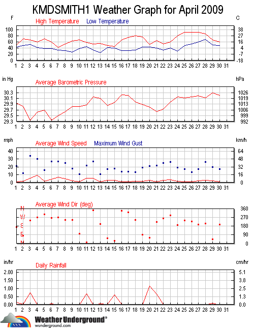
| April 2009: | High | Low | Rainfall | Snowfall | Snow on | High | High | High | |
| Temp | Temp | or Melted | Icefall | Ground | Wind | Wind | Wind | ||
| Date | Conditions | (F) | (F) | Snow (in.) | (in.) | (in.) | (m.p.h.) | Direction | Time |
| 1st | Overnight showers, Periodic rain showers (0.14"), Cool, Windy | 51 | 44 | 0.14 | 21 | NE | 2:45 AM | ||
| 2nd | AM haze, Mostly cloudy, Warmer, PM shower (0.01"), Breezy | 71 | 48 | 0.01 | 12 | NE | 10:!5 AM | ||
| 3rd | Overnight showers, Rain throughout day, Very windy | 67 | 52 | 0.75 | 34 | WSW | 6:15 PM | ||
| 4th | Mostly sunny, Cooler, Very Windy | 61 | 42 | 30 | W | 2:15 PM | |||
| 5th | Partly cloudy, Warmer, Breezy | 70 | 39 | 16 | SSW | 9:30 AM | |||
| 6th | AM showers (0.04"), Cloudy, Cooler, Windy | 60 | 39 | 0.04 | 27 | W | 9:30 PM | ||
| 7th | Cloudy, Flurries, Much colder, Windy | 43 | 34 | 27 | W | 10:30 AM | |||
| 8th | Overnight flurries, Partly cloudy, Not quite as cool, Windy | 54 | 32 | 25 | WSW | 11:15 AM | |||
| 9th | Sunny, Warmer, Breezy | 64 | 27 | 18 | WSW | 3:00 PM | |||
| 10th | *Good Friday Holiday* Slightly warmer, Partly sunny, Breezy | 67 | 39 | 11 | NE | 12:00 PM | |||
| 11th | AM rain into midday (0.66"), Cooler, Windy | 60 | 44 | 0.66 | 22 | N | 12:00 PM | ||
| 12th | Mostly sunny, Cooler, Windy | 54 | 34 | 27 | N | 2:45 PM | |||
| 13th | Cold AM, Mostly cloudy, PM showers (0.05"), Breezy | 56 | 25 | 0.05 | 11 | E | 4:$5 PM | ||
| 14th | Cloudy, AM showers (0.03"), Flurries, Much colder, Windy | 49 | 43 | 0.03 | 17 | NE | 5:00 PM | ||
| 15th | AM drizzle and rain showers (0.60"), Cooler, Breezy | 46 | 39 | 0.60 | 18 | NE | 1:00 PM | ||
| 16th | Cloudy, PM light shower(0.01"), Warmer, Breezy | 68 | 32 | 0.01 | 14 | SE | 4:$5 PM | ||
| 17th | Partly cloudy, Warmer, Breezy | 76 | 32 | 14 | N | 3:00 PM | |||
| 18th | Mostly sunny, Warm, Breezy | 80 | 34 | 13 | WSW | 3:00 PM | |||
| 19th | Mostly cloudy, Slightly cooler, Breezy | 78 | 44 | 19 | SE | 9:15 PM | |||
| 20th | Overnight rain continuing throughout day (1.13"), Much cooler, Windy | 53 | 44 | 1.13 | 21 | ENE | 8:15 AM | ||
| 21st | AM fog, PM t/storm and showers(0.64"), Slightly warmer, Windy | 66 | 40 | 0.64 | 22 | N | 3:45 PM | ||
| 22nd | Mostly cloudy, Cooler, PM shower (0.02"), Windy | 54 | 33 | 0.02 | 25 | WSW | 4:00 PM | ||
| 23rd | Sunny, Warmer, Windy | 61 | 40 | 26 | W | 1:00 PM | |||
| 24th | Cold AM, Mostly sunny, Much warmer, Breezy | 80 | 31 | 19 | SSW | 5:00 PM | |||
| 25th | Partly cloudy, Hot (record high in nearby Hagerstown), Breezy | 93 | 48 | 17 | S | 12:30 PM | |||
| 26th | Sunny, Continued hot, Breezy | 92 | 54 | 13 | SSW | 3:15 PM | |||
| 27th | Sunny, Continued hot, Breezy | 92 | 60 | 17 | SSW | 6:00 PM | |||
| 28th | Mostly sunny, Not quite as hot, Windy | 87 | 67 | 26 | SSW | 9:00 PM | |||
| 29th | Mostly cloudy, Much cooler, AM & PM showers (0.07"), Windy | 67 | 50 | 0.07 | 20 | ENE | 3:30 AM | ||
| 30th | Mostly cloudy, Cooler, Late night shower (0.01"), Breezy | 60 | 50 | 0.01 | 17 | SSW | 8:30 PM | ||
                   MONTHLY CLIMATOLOGICAL SUMMARY for APR. 2009

NAME: SMBG   CITY: SMITHSBURG   STATE: MD
ELEV:   680 ft  LAT: 39° 38' 00" N  LONG: 77° 36' 00" W

                   TEMPERATURE (°F), RAIN  (in), WIND SPEED (mph)

                                      HEAT  COOL        AVG
    MEAN                              DEG   DEG         WIND                 DOM
DAY TEMP  HIGH   TIME   LOW    TIME   DAYS  DAYS  RAIN  SPEED HIGH   TIME    DIR
------------------------------------------------------------------------------------
 1  48.0  51.0   7:00p  44.1   6:30a  17.0   0.0  0.14   0.9  21.0   2:45a    NE
 2  55.9  70.9   2:30p  48.0   7:30a   9.5   0.4  0.01   1.4  12.0  10:15a    NE
 3  57.8  66.8   2:00p  52.3  11:15p   7.3   0.1  0.75   5.3  34.0   6:15p   WSW
 4  51.6  60.7   5:00p  41.9   7:30a  13.4   0.0  0.00   9.2  30.0   2:15p     W
 5  54.3  70.1   6:30p  39.3   7:00a  11.4   0.7  0.00   1.5  16.0   9:30a   SSW
 6  52.3  60.2  12:30a  39.3  12:00m  12.7   0.0  0.04   4.3  27.0   9:30p     W
 7  37.7  42.9   2:15p  33.8   7:15a  27.3   0.0  0.00   6.6  27.0  10:30a     W
 8  43.5  54.1   5:45p  32.5   6:45a  21.5   0.0  0.00   5.1  25.0  11:15a   WSW
 9  46.7  63.7   5:00p  26.6   7:30a  18.3   0.0  0.00   2.1  18.0   3:00p   WSW
10  53.4  67.4   2:45p  39.2   1:45a  11.9   0.3  0.00   0.7  11.0  12:00p    NE
11  50.1  59.6   6:00p  44.3  12:00m  14.9   0.0  0.66   5.6  22.0  12:00p     N
12  43.7  54.5   6:00p  34.1   7:30a  21.3   0.0  0.00   5.4  27.0   2:45p     N
13  41.0  55.7   3:30p  25.1   6:45a  24.0   0.0  0.05   0.9  11.0   4:45p     E
14  45.4  48.9   5:00p  42.6   3:30a  19.6   0.0  0.03   3.1  17.0   5:00p    NE
15  43.1  45.8  10:45a  39.3  12:00m  21.9   0.0  0.60   2.6  18.0   1:00p    NE
16  48.1  67.9   6:15p  31.6   5:00a  17.1   0.3  0.01   0.8  14.0   4:45p    SE
17  54.0  76.1   6:15p  32.4   7:15a  13.0   2.0  0.00   1.1  14.0   3:00p     N
18  58.8  79.9   6:00p  34.4   7:00a  10.5   4.3  0.00   1.3  13.0   3:00p   WSW
19  57.5  77.6   1:45p  43.6   5:30a   9.6   2.1  0.00   1.4  19.0   9:15p    SE
20  48.3  52.6   4:45p  43.9   8:00a  16.7   0.0  1.13   3.0  21.0   8:15a   ENE
21  49.3  66.1   3:15p  40.1  12:00m  15.7   0.0  0.64   1.0  22.0   3:45p     N
22  44.5  53.9   3:30p  33.4   7:00a  20.5   0.0  0.02   3.0  25.0   4:00p   WSW
23  49.3  61.3   5:45p  40.2   4:45a  15.7   0.0  0.00   3.8  26.0   1:00p     W
24  57.6  79.8   5:45p  31.3   6:30a  11.9   4.5  0.00   1.6  19.0   5:00p   SSW
25  70.3  92.7   5:00p  48.5   7:00a   4.6   9.9  0.00   1.1  17.0  12:30p     S
26  76.0  92.5   4:45p  53.6   7:00a   1.7  12.6  0.00   0.9  13.0   3:15p   SSW
27  78.2  92.1   4:15p  60.2   4:30a   0.3  13.5  0.00   2.3  17.0   6:00p   SSW
28  76.6  87.4   4:45p  67.4  12:00m   0.0  11.6  0.00   3.0  26.0   9:00p   SSW
29  55.5  67.4  12:15a  50.4  11:00p   9.6   0.1  0.07   2.3  20.0   3:30a   ENE
30  55.0  59.8   2:15p  49.6   5:45a  10.0   0.0  0.01   1.3  17.0   8:30p   SSW
-------------------------------------------------------------------------------------
    53.5  92.7    25    25.1    13   408.9  62.4  4.16   2.8  34.0     3     SSW

Max >=  90.0:  3
Max <=  32.0:  0
Min <=  32.0:  4
Min <=   0.0:  0
Max Rain: 1.13 ON 04/20/09
Days of Rain: 11 (>.01 in) 6 (>.1 in) 1 (>1 in)
Heat Base:  65.0  Cool Base:  65.0  Method: Integration
Back To Top