| Home | Current Weather | Weather History | About the Weather Station | Weather Forecast & Alerts!! |
| Smithsburg Area | Washington County | Partners/Weather Links | Monthly Almanack | Contact Us |
![]() Weather Station Notes - February 2014
Weather Station Notes - February 2014
![]()
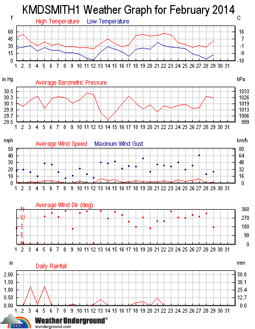
| February 2014: | Average | High | Low | Rainfall | Snowfall | Snow on | Peak | High | DOMINATE | |
| Mean Tmp | Temp | Temp | or Melted | Icefall | Ground | Wind | Wind | Wind | ||
| Date | Conditions | (F) | (F) | (F) | Snow (in.) | (in.) | (in.) | (m.p.h.) | Time | Direction |
| 1st | Partly sunny, Mild temps, Breezy | 37.3 | 49.1 | 25.3 | 1.0 | 18 | 4:15 PM | S | ||
| 2nd | Cloudy, Continued mild temps, Windy | 40.6 | 53.9 | 28.4 | 1.0 | 20 | 7:30 PM | N | ||
| 3rd | Overnight rain then sleet then snow thru mid PM (3.4")(melted=1.19"), Colder temps, Breezy | 33.3 | 39.3 | 30.3 | 1.19 | 3.4 | 3.4 | 16 | 2:30 PM | N |
| 4th | Cloudy, Colder temps, Late PM freezing rain/sleet (0.2")(melted=0.09"), Breezy | 27.0 | 31.0 | 20.0 | 0.09 | 0.2 | 3.0 | 10 | 11:45 PM | N |
| 5th | Frz-rain/sleet con't from 4th thru late AM (0.2")(melted=1.23")(Event=0.4"), Cold temps, Windy | 32.2 | 38.5 | 27.0 | 1.23 | 0.2 | 3.0 | 29 | 6:15 PM | NW |
| 6th | Cloudy, Cold temps, Windy | 26.3 | 32.4 | 22.1 | 2.0 | 27 | 1:15 AM | NNW | ||
| 7th | Partly cloudy, Continued cold temps, Breezy | 27.9 | 34.9 | 21.4 | 2.0 | 16 | 7:15 PM | W | ||
| 8th | Cloudy, Colder temps, Snow flurries | 22.9 | 29.4 | 16.1 | 2.0 | 7 | 1:15 PM | NE | ||
| 9th | Cloudy, Mid-PM snowfall (1.7")(melted=0.07"), Cold temps, Breezy | 24.9 | 29.7 | 16.1 | 0.07 | 1.7 | 3.7 | 11 | 11:30 AM | NE |
| 10th | Mostly sunny, Continued cold temps, Windy | 22.0 | 26.7 | 12.4 | 3.0 | 21 | 1:45 AM | NW | ||
| 11th | Very cold AM (5F), Mostly sunny, Cold all day, Breezy | 14.8 | 27.5 | 4.7 | 3.0 | 13 | 12:00 PM | NNW | ||
| 12th | Very cold AM (2F), Increasing clouds, Late PM snow (1.0")(Melted = 0.06"), Cold all day | 14.5 | 25.0 | 2.0 | 0.06 | 1.0 | 4.0 | 8 | 6:00 PM | ENE |
| 13th | Snow o/night into Late AM & some late PM (8.1")(Melted=0.41")(Event=9.1"), Not as cold, Very Windy | 28.3 | 35.3 | 18.3 | 0.41 | 8.1 | 12.0 | 30 | 3:00 PM | N |
| 14th | Cloudy to Sunny, Mild temps, Windy, Good deal of snow melt today | 36.1 | 44.9 | 29.3 | 9.0 | 29 | 12:30 PM | W | ||
| 15th | Snow from mid-AM until early PM (0.7")(melted = 0.02"), Very Windy (32 mph), some drifting snow | 31.3 | 35.2 | 23.6 | 0.02 | 0.7 | 8.0 | 32 | 6:00 PM | NW |
| 16th | Cloudy, PM snow flurries, Cold, Breezy | 24.2 | 29.5 | 18.9 | Trace | 8.0 | 18 | 12:15 AM | N | |
| 17th | Very cold AM (9F), Partly cloudy, High temp at freezing point, Snow starting just before midnight | 22.8 | 32.5 | 8.8 | 8.0 | 25 | 11:45 PM | SSE | ||
| 18th | Overnight snow (1.4")(melted=0.19"), Mild temps in PM, Clearing, Windy | 34.9 | 52.5 | 23.8 | 0.19 | 1.4 | 7.0 | 24 | 1:00 PM | SSE |
| 19th | Mid-AM Freezing Rain (Trace) then rain (0.24"), Mild temps, Very Windy (36 mph) | 38.2 | 55.0 | 26.0 | 0.24 | Trace | 5.0 | 36 | 5:30 PM | W |
| 20th | Partly sunny, Continued mild temps, Breezy | 39.4 | 51.3 | 23.5 | 4.0 | 17 | 11:45 AM | SSE | ||
| 21st | Partly to mostly cloudy, Late AM rain (0.47"), Continued mild temps, Windy | 44.0 | 52.6 | 37.0 | 0.47 | 3.0 | 27 | 11:00 AM | WSW | |
| 22nd | Sunny, Very mild temps, Windy | 45.9 | 56.9 | 30.3 | 2.0 | 26 | 1:00 PM | WSW | ||
| 23rd | Partly sunny, Continued mild temps, Late PM shower (0.02"), Windy | 39.9 | 53.1 | 27.9 | 0.02 | 2.0 | 24 | 6:00 PM | NNW | |
| 24th | Sunny, Cool temps, Very Windy (30 mph) | 32.6 | 37.6 | 27.2 | 1.0 | 30 | 3:00 PM | W | ||
| 25th | Mostly cloudy, AM snow showers, Colder temps, Windy | 28.2 | 33.8 | 24.7 | Trace | 1.0 | 20 | 4:15 PM | W | |
| 26th | Cold AM, AM snow flurries, Partly cloudy, Cold temps, Windy | 24.9 | 28.4 | 14.4 | 1.0 | 26 | 12:00 PM | NNW | ||
| 27th | Cold AM, Partly cloudy, Cold temps, Period of extreme winds (41 mph) | 19.3 | 31.3 | 10.2 | Trace | 41 | 1:45 PM | NNW | ||
| 28th | Very cold AM (3F), Sunny, Cold all day, Breezy | 15.4 | 27.6 | 3.4 | Trace | 13 | 12:30 AM | NNW | ||
| Average | Average | Average | Total | Total | Average | Dominate | ||||
| Averages/Totals/Dominate Wind Direction -----> | 29.6 | 38.4 | 20.5 | 3.99 | 16.7 | 22 | NNW | |||
| Mean Tmp | High | Low | Rainfall | Snow/Ice | Peak Wind | Direction | ||||
                 MONTHLY CLIMATOLOGICAL SUMMARY for FEB. 2014

NAME: SMBG   CITY: SMITHSBURG   STATE: MD
ELEV:   680 ft  LAT: 39° 38' 00" N  LONG: 77° 36' 00" W

                   TEMPERATURE (°F), RAIN  (in), WIND SPEED (mph)

                                      HEAT  COOL        AVG
    MEAN                              DEG   DEG         WIND                 DOM
DAY TEMP  HIGH   TIME   LOW    TIME   DAYS  DAYS  RAIN  SPEED HIGH   TIME    DIR
------------------------------------------------------------------------------------
 1  37.3  49.1   3:45p  25.3   7:30a  27.7   0.0  0.00   1.9  18.0   4:15p     S
 2  40.6  53.9   3:00p  28.4   4:15a  24.4   0.0  0.00   0.7  20.0   7:30p     N
 3  33.3  39.3  12:15a  30.3  12:00m  31.7   0.0  1.19   1.7  16.0   2:30p     N
 4  27.0  31.0   3:15p  20.0   7:30a  38.0   0.0  0.09   1.2  10.0  11:45p     N
 5  32.2  38.5   6:15p  27.0  12:15a  32.8   0.0  1.23   3.0  29.0   6:15p    NW
 6  26.3  32.4   5:00p  22.1   8:00a  38.7   0.0  0.00   3.0  27.0   1:15a   NNW
 7  27.9  34.9   5:00p  21.4   1:15a  37.1   0.0  0.00   2.2  16.0   7:15p     W
 8  22.9  29.4   2:00p  16.1  12:00m  42.1   0.0  0.00   0.3   7.0   1:15p    NE
 9  24.9  29.7   3:30p  16.1  12:15a  40.1   0.0  0.07   0.4  11.0  11:30a    NE
10  22.0  26.7   3:00p  12.4  12:00m  43.0   0.0  0.00   3.0  21.0   1:45a    NW
11  14.8  27.5   5:15p   4.7   7:45a  50.2   0.0  0.00   0.6  13.0  12:00p   NNW
12  14.5  25.0   3:30p   2.0   7:45a  50.5   0.0  0.06   0.8   8.0   6:00p   ENE
13  28.3  35.3  11:45p  18.3  12:15a  36.8   0.0  0.41   6.2  30.0   3:00p     N
14  36.1  44.9   5:30p  29.3   5:45a  28.9   0.0  0.00   3.6  29.0  12:30p     W
15  31.3  35.2  12:30a  23.6  12:00m  33.7   0.0  0.02   5.3  32.0   6:00p    NW
16  24.2  29.5   1:00p  18.9   6:30a  40.8   0.0  0.00   0.9  18.0  12:15a     N
17  22.8  32.5   5:30p   8.8   7:45a  42.2   0.0  0.00   1.9  25.0  11:45p   SSE
18  34.9  52.5   5:15p  23.8  12:30a  30.1   0.0  0.19   3.0  24.0   1:00p   SSE
19  38.2  55.0   5:00p  26.0   5:00a  26.8   0.0  0.24   2.7  36.0   5:30p     W
20  39.4  51.3  12:45p  23.5   7:15a  25.6   0.0  0.00   1.8  17.0  11:45a   SSE
21  44.0  52.6   5:00p  37.0   7:30a  21.0   0.0  0.47   1.9  27.0  11:00a   WSW
22  45.9  56.9   2:45p  30.3  12:00m  19.1   0.0  0.00   3.2  26.0   1:00p   WSW
23  39.9  53.1   4:15p  27.9   7:00a  25.1   0.0  0.02   1.4  24.0   6:00p   NNW
24  32.6  37.6   2:00p  27.2   7:00a  32.4   0.0  0.00   5.2  30.0   3:00p     W
25  28.2  33.8   3:30p  24.7  10:15p  36.8   0.0  0.00   2.8  20.0   4:15p     W
26  24.9  28.4   6:00a  14.4  12:00m  40.1   0.0  0.00   4.3  26.0  12:00p   NNW
27  19.3  31.3   2:30p  10.2   5:45a  45.7   0.0  0.00   6.7  41.0   1:45p   NNW
28  15.4  27.6   5:00p   3.4   7:15a  49.6   0.0  0.00   0.7  13.0  12:30a   NNW
-------------------------------------------------------------------------------------
    29.6  56.9    22     2.0    12   991.0   0.0  3.99   2.5  41.0    27     NNW

Max >=  90.0:  0
Max <=  32.0: 10
Min <=  32.0: 27
Min <=   0.0:  0
Max Rain: 1.23 ON 02/05/14
Days of Rain: 11 (>.01 in) 6 (>.1 in) 2 (>1 in)
Heat Base:  65.0  Cool Base:  65.0  Method: Integration
Back To Top