| Home | Current Weather | Weather History | About the Weather Station | Weather Forecast & Alerts!! |
| Smithsburg Area | Washington County | Partners/Weather Links | Monthly Almanack | Contact Us |
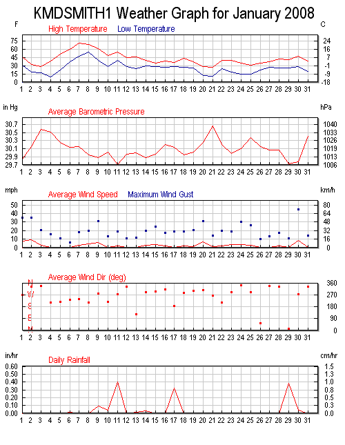
![]() Weather Station Notes - January 2008
Weather Station Notes - January 2008
![]()
| January 2008: | High | Low | Rainfall | Snowfall | Snow on | High | High | High | |
| Temp | Temp | or Melted | Icefall | Ground | Wind | Wind | Wind | ||
| Date | Conditions | (F) | (F) | Snow (in.) | (in.) | (in.) | (m.p.h.) | Direction | Time |
| 1st | ** NEW YEAR'S DAY ** Cloudy, Very windy, Temps falling | 45 | 31 | 35 | WNW | 4:45 PM | |||
| 2nd | Cloudy, Much colder, Very Windy | 32 | 18 | 35 | N | 3:00 PM | |||
| 3rd | Mostly cloudy, Colder, Windy | 28 | 17 | 21 | N | 11:15 AM | |||
| 4th | Very cold A.M., Slightly warmer P.M., Mostly sunny, Breezy | 38 | 10 | 16 | SW | 10:15 AM | |||
| 5th | Partly cloudy, Warmer, Breezy, P.M. sprinkles | 50 | 22 | Trace | 11 | SSW | 11:15 AM | ||
| 6th | Overnight shower, Cloudy, Warmer | 60 | 37 | 0.01 | 6 | SSE | 11:30 AM | ||
| 7th | Mostly cloudy, Warm (record high in nearby Hagerstown), Breezy | 70 | 47 | 18 | SW | 2:15 PM | |||
| 8th | Mostly sunny, Continued warm, Windy | 68 | 55 | 20 | SSW | 4:30 PM | |||
| 9th | Warm A.M. with showers, Very Windy, Temps falling | 60 | 39 | 0.09 | 31 | WNW | 8:15 AM | ||
| 10th | Cooler, Cloudy, P.M. showers, Breezy | 48 | 28 | 0.04 | 13 | S | 8:30 PM | ||
| 11th | Overnight and A.M. rain, warmer, Breezy | 54 | 39 | 0.40 | 19 | WNW | 9:45 AM | ||
| 12th | Mostly cloudy, Cooler, Breezy | 44 | 27 | 11 | N | 2:45 AM | |||
| 13th | A.M. fog, Cloudy, Breezy | 46 | 24 | 0.01 | 12 | SE | 10:45 AM | ||
| 14th | A.M. rain/snow showers, Cloudy, Windy | 39 | 29 | 0.03 | Trace | 20 | WNW | 11:00 AM | |
| 15th | Colder, Cloudy, Snow flurries, Windy | 34 | 28 | 25 | WNW | 2:15 PM | |||
| 16th | Cloudy, Slightly warmer, Breezy | 38 | 27 | 17 | WNW | 3:00 AM | |||
| 17th | Cloudy, Mid-A.M. snow thru evening changing to freezing rain accum = 3.0", Breezy | 35 | 28 | 0.32 | 3.0" | 3.0" | 19 | S | 10:45 AM |
| 18th | Mostly sunny, Slightly warmer, Breezy | 43 | 26 | 1.0" | 19 | WNW | 1:45 PM | ||
| 19th | Costly cloudy, Cooler, Windy | 36 | 26 | 1.0" | 22 | WNW | 12:00 M | ||
| 20th | Very cold with falling temps, Very Windy | 28 | 12 | 31 | WNW | 12:15 PM | |||
| 21st | Continued very cold, Sunny, Breezy | 27 | 10 | 14 | WNW | 11:45 PM | |||
| 22nd | Slightly warmer, Cloudy, Windy | 40 | 24 | 20 | SSW | 5:00 AM | |||
| 23rd | Continued cold, Sunny, Breezy | 39 | 17 | 19 | WNW | 1:00 AM | |||
| 24th | Cold, Cloudy, Snow flurries, Very windy | 35 | 15 | 30 | N | 8:15 PM | |||
| 25th | Partly cloudy, continued cold | 31 | 15 | 26 | W | 1:45 AM | |||
| 26th | Mostly cloudy, Not quite as cold | 34 | 22 | 10 | N | 7:00 AM | |||
| 27th | Partly cloudy, Slightly warmer, Breezy | 37 | 27 | 13 | NW | 4:30 PM | |||
| 28th | Cloudy, Slightly warmer, Breezy | 41 | 26 | 17 | N | 1:15 PM | |||
| 29th | Cloudy, Rainy, Breezy | 40 | 26 | 0.38 | 11 | N | 8:15 AM | ||
| 30th | Overnight shower, Mostly cloudy, Warmer, Extremely Windy!! | 46 | 28 | 0.04 | 45 | WNW | 7:00 AM | ||
| 31st | Sunny, Cold, Breezy | 38 | 20 | 14 | N | 12:45 AM | |||
                   MONTHLY CLIMATOLOGICAL SUMMARY for JAN. 2008

NAME: SMBG   CITY: SMITHSBURG   STATE: MD
ELEV:   680 ft  LAT: 39° 38' 00" N  LONG: 77° 36' 00" W

                   TEMPERATURE (°F), RAIN  (in), WIND SPEED (mph)

                                      HEAT  COOL        AVG
    MEAN                              DEG   DEG         WIND                 DOM
DAY TEMP  HIGH   TIME   LOW    TIME   DAYS  DAYS  RAIN  SPEED HIGH   TIME    DIR
------------------------------------------------------------------------------------
 1  39.1  45.1  10:15a  30.6  12:00m  25.9   0.0  0.00   7.6  35.0   4:45p   WNW
 2  26.1  31.8   2:15p  18.3  12:00m  38.9   0.0  0.00   9.3  35.0   3:00p     N
 3  21.2  28.4   3:30p  16.7   5:30a  43.8   0.0  0.00   3.1  21.0  11:15a     N
 4  25.3  38.2   1:00p   9.9   7:00a  39.7   0.0  0.00   0.6  16.0  10:15a    SW
 5  35.1  50.1   1:45p  21.8   8:15a  29.9   0.0  0.00   0.6  11.0  11:15a   SSW
 6  46.2  59.9   3:15p  37.2   3:45a  18.8   0.0  0.01   0.1   6.0  11:30a   SSE
 7  59.4  70.3   3:00p  47.3  12:30a   6.4   0.8  0.00   2.9  18.0   2:15p    SW
 8  60.9  67.8   1:30p  54.7   8:00a   4.5   0.4  0.00   4.5  20.0   4:30p   SSW
 9  53.5  60.5   5:15a  39.2  11:45p  11.5   0.0  0.09   6.1  31.0   8:15a   WNW
10  39.1  48.3   2:30p  27.9   8:00a  25.9   0.0  0.04   0.7  13.0   8:30p     S
11  45.0  53.9   3:45p  39.3   4:30a  20.0   0.0  0.40   2.2  19.0   9:45a   WNW
12  38.8  43.9   3:00p  27.5  12:00m  26.2   0.0  0.00   0.8  11.0   2:45a     N
13  34.7  45.7   3:00p  23.8   6:00a  30.3   0.0  0.01   0.6  12.0  10:45a    SE
14  33.7  38.8  12:00p  28.7  12:00m  31.3   0.0  0.03   2.5  20.0  11:00a   WNW
15  30.2  34.0   1:15p  28.1   7:45a  34.8   0.0  0.00   3.6  25.0   2:15p   WNW
16  31.0  37.8   3:30p  27.0  10:15p  34.0   0.0  0.00   1.9  17.0   3:00a   WNW
17  31.5  35.3  10:30a  27.6  12:15a  33.5   0.0  0.32   0.5  19.0  10:45a     S
18  34.0  43.2   1:45p  26.4  11:45p  31.0   0.0  0.00   1.8  19.0   1:45p   WNW
19  32.1  36.3   2:15p  25.7   1:00a  32.9   0.0  0.00   1.7  22.0  12:00m   WNW
20  16.4  28.2  12:15a  11.6  10:45p  48.6   0.0  0.00   6.9  31.0  12:15p   WNW
21  18.4  26.9   3:45p  10.5   5:30a  46.6   0.0  0.00   1.5  14.0  11:45p   WNW
22  31.9  39.8  11:45p  23.9   6:45a  33.1   0.0  0.00   2.3  20.0   5:00a   SSW
23  31.1  39.5  12:15a  17.3  12:00m  33.9   0.0  0.00   3.4  19.0   1:00a   WNW
24  24.6  34.7   1:45p  14.9   1:30a  40.4   0.0  0.00   3.9  30.0   8:15p     N
25  22.5  31.0   4:00p  14.9   7:45a  42.5   0.0  0.00   2.6  26.0   1:45a     W
26  28.0  33.8   1:15p  22.4   2:00a  37.0   0.0  0.00   0.3  10.0   7:00a     N
27  31.3  37.3   2:45p  26.9   6:45a  33.7   0.0  0.00   0.6  13.0   4:30p    NW
28  33.5  41.3   4:00p  25.8  11:30p  31.5   0.0  0.00   1.9  17.0   1:15p     N
29  35.8  40.3   3:45p  26.0  12:15a  29.2   0.0  0.38   0.2  11.0   8:15a     N
30  37.1  46.4   3:30a  28.4  12:00m  27.9   0.0  0.04   8.2  45.0   7:00a   WNW
31  29.7  37.9   1:30p  19.7   8:00a  35.3   0.0  0.00   0.8  14.0  12:45a     N
-------------------------------------------------------------------------------------
    34.1  70.3     7     9.9     4   959.0   1.2  1.32   2.7  45.0    30     WNW

Max >=  90.0:  0
Max <=  32.0:  5
Min <=  32.0: 26
Min <=   0.0:  0
Max Rain: 0.40 ON 01/11/08
Days of Rain: 7 (>.01 in) 3 (>.1 in) 0 (>1 in)
Heat Base:  65.0  Cool Base:  65.0  Method: Integration
Method: Integration
Back To Top