 Weather Station Notes - December 2012

|
December 2012: |
Average |
High |
Low |
Rainfall |
Snowfall |
Snow on |
Peak |
High |
DOMINATE |
| |
|
Mean Tmp |
Temp |
Temp |
or Melted |
Icefall |
Ground |
Wind |
Wind |
Wind |
| Date |
Conditions |
(F) |
(F) |
(F) |
Snow (in.) |
(in.) |
(in.) |
(m.p.h.) |
Time |
Direction |
| 1st |
Mostly sunny, Cool |
36.5 |
49 |
28 |
|
|
|
9 |
3:00 PM |
ESE |
| 2nd |
Mostly cloudy, Warmer, Late PM showers (0.02"),
Breezy |
41.6 |
56 |
29 |
0.02 |
|
|
11 |
1:30 PM |
NE |
| 3rd |
Partly cloudy, Much warmer |
54.0 |
66 |
43 |
|
|
|
8 |
11:00 AM |
S |
| 4th |
Partly cloudy, Continued unseasonably warm, Breezy |
58.6 |
71 |
45 |
|
|
|
15 |
6:00 PM |
S |
| 5th |
Mostly sunny, Warm AM then declining temps, Very
Windy (31mph) |
47.6 |
63 |
33 |
|
|
|
31 |
4:00 PM |
NW |
| 6th |
Partly cloudy, Cool |
31.6 |
42 |
21 |
|
|
|
8 |
1:30 PM |
S |
| 7th |
AM showers and occasional showers (0.14"), Cloudy,
Continued cool |
37.9 |
41 |
29 |
0.14 |
|
|
8 |
1:45 AM |
ESE |
| 8th |
AM fog, Cloudy, Not as cool, PM showers (0.01") |
44.6 |
55 |
37 |
0.01 |
|
|
8 |
1:00 PM |
N |
| 9th |
Overnight rain and also periodically throughout day
(0.33"), Some fog, Cool, Breezy |
45.5 |
48 |
43 |
0.33 |
|
|
11 |
7:15 AM |
NE |
| 10th |
AM fog, Cloudy, Not quite as cool, Showers (0.10"),
Windy |
49.7 |
53 |
44 |
0.10 |
|
|
26 |
11:45 PM |
NW |
| 11th |
Increasing clouds, Cooler, windy |
40.8 |
46 |
32 |
|
|
|
28 |
10:30 AM |
NW |
| 12th |
Mostly cloudy, Much cooler |
32.4 |
39 |
28 |
|
|
|
9 |
11:30 AM |
NNW |
| 13th |
Cold AM, Sunny, Not as cool |
31.0 |
45 |
21 |
|
|
|
4 |
11:30 AM |
N |
| 14th |
Cold, AM, Sunny, Mild |
32.7 |
52 |
20 |
|
|
|
8 |
10:15 AM |
S |
| 15th |
Increasing clouds, Continued mild, Breezy |
38.8 |
52 |
27 |
|
|
|
16 |
9:30 PM |
SSE |
| 16th |
Overnight light shower (0.01"), Cloudy, Some fog,
Drizzle, Mild temps, Breezy |
45.0 |
49 |
41 |
0.01 |
|
|
15 |
1:00 AM |
SSE |
| 17th |
Cloudy, Continued mild, Late PM rain (0.24"), Breezy |
45.0 |
50 |
39 |
0.24 |
|
|
14 |
6:15 PM |
ESE |
| 18th |
AM Dense fog, Partial clearing, Continued mild, Very
Windy (30 mph) |
45.1 |
52 |
38 |
0.01 |
|
|
30 |
12:45 PM |
Wind |
| 19th |
Partly sunny, Mild temps, Windy |
40.9 |
48 |
34 |
|
|
|
20 |
12:00 PM |
NNW |
| 20th |
Cloudy, Continued mild, PM rain showers (0.26"),
Windy |
37.6 |
48 |
29 |
0.26 |
|
|
25 |
11:00 PM |
NE |
| 21st |
Overnight rain (0.42"), Mild start but then falling
temps, A few snow flurries, Windy |
38.0 |
49 |
34 |
0.42 |
|
|
26 |
6:15 PM |
WSW |
| 22nd |
Very Windy all day until evening( 34 mph), Mostly
cloudy, Cold, A few snow flurries |
34.9 |
38 |
30 |
|
|
|
34 |
4:15 AM |
W |
| 23rd |
Sunny, Not as cold, Breezy |
34.6 |
46 |
26 |
|
|
|
12 |
1:30 PM |
S |
| 24th |
Cloudy, Snow mid to late PM (2.8")(liquid content =
0.92"), Falling temps, Some fog late |
29.8 |
37 |
23 |
0.25 |
2.8 |
2.8 |
8 |
9:45 AM |
NE |
| 25th |
*WHITE CHRISTMAS*
AM
fog, Partly sunny, Not as cold, Breezy |
33.9 |
40 |
31 |
|
|
2.0 |
13 |
10:45 PM |
NE |
| 26th |
AM snow changed to sleet & frz/rain until late PM
(3.4")(liquid content=0.92"), Cold, Windy |
31.0 |
34 |
28 |
0.92 |
3.4 |
5.0 |
24 |
9:00 AM |
NE |
| 27th |
Cloudy, Continued cold, Few snow flurries, Very
Windy (30 mph) |
34.1 |
37 |
32 |
|
|
4.0 |
30 |
10:15 AM |
NW |
| 28th |
Mostly Sunny, Continued cold, Breezy |
32.8 |
37 |
27 |
|
|
3.0 |
16 |
5:30 AM |
NW |
| 29th |
Snow from early AM until early PM (2.0")(liquid
content = 0.21"), Cold, Windy |
33.1 |
36 |
28 |
0.21 |
2.0 |
4.0 |
24 |
6:45 PM |
W |
| 30th |
Mostly cloudy, Continued cold, Windy |
32.5 |
35 |
26 |
|
|
3.0 |
29 |
4:00 PM |
NW |
| 31st |
Cold AM, Mostly cloudy, Cold then rising temps late
in day (2012 ended at 40F), Breezy |
30.7 |
40 |
21 |
|
|
2.0 |
12 |
10:45 PM |
S |
| |
|
Average |
Average |
Average |
Total |
Total |
|
Average |
|
Dominate |
| |
Averages/Totals/Dominate Wind Direction -----> |
38.8 |
47 |
31 |
2.92 |
8.2 |
|
17 |
|
NW |
| |
|
Mean Tmp |
High |
Low |
Rainfall |
Snowfall |
|
Peak Wind |
|
Direction |
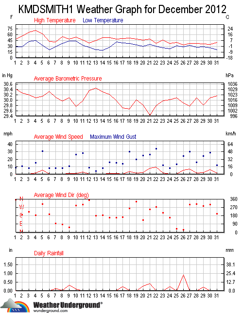
                  MONTHLY CLIMATOLOGICAL SUMMARY for DEC. 2012

NAME: SMBG   CITY: SMITHSBURG   STATE: MD
ELEV:   680 ft  LAT: 39° 38' 00" N  LONG: 77° 36' 00" W

                   TEMPERATURE (°F), RAIN  (in), WIND SPEED (mph)

                                      HEAT  COOL        AVG
    MEAN                              DEG   DEG         WIND                 DOM
DAY TEMP  HIGH   TIME   LOW    TIME   DAYS  DAYS  RAIN  SPEED HIGH   TIME    DIR
------------------------------------------------------------------------------------
 1  36.5  49.4   2:30p  28.5   7:30a  28.5   0.0  0.00   0.6   9.0   3:00p   ESE
 2  41.6  56.2   1:45p  28.8   3:00a  23.4   0.0  0.02   0.4  11.0   1:30p    NE
 3  54.0  66.4  12:15p  42.6   8:30a  11.2   0.1  0.00   0.3   8.0  11:00a     S
 4  58.6  71.3   1:30p  45.4   6:45a   7.3   0.9  0.00   1.8  15.0   6:00p     S
 5  47.6  62.9  12:15a  32.7  12:00m  17.4   0.0  0.00   5.5  31.0   4:00p    NW
 6  31.6  41.9   2:15p  21.3   8:00a  33.4   0.0  0.00   0.3   8.0   1:30p     S
 7  37.9  40.8   2:00p  29.1  12:15a  27.1   0.0  0.14   0.2   8.0   1:45a   ESE
 8  44.6  54.7   3:00p  37.3   5:00a  20.4   0.0  0.01   0.3   8.0   1:00p     N
 9  45.5  48.3  12:15a  43.2   4:30a  19.5   0.0  0.33   0.8  11.0   7:15a    NE
10  49.7  53.5   4:00p  44.2  12:15a  15.3   0.0  0.10   0.8  26.0  11:45p    NW
11  40.8  46.0  11:15a  32.4  12:00m  24.2   0.0  0.00   2.7  28.0  10:30a    NW
12  32.4  38.9  12:45p  27.6   8:00a  32.6   0.0  0.00   0.1   9.0  11:30a   NNW
13  31.0  45.5   3:00p  20.6   8:00a  34.0   0.0  0.00   0.0   4.0  11:30a     N
14  32.7  52.0   3:15p  19.7   7:30a  32.3   0.0  0.00   0.3   8.0  10:15a     S
15  38.8  52.2   2:45p  26.6   8:00a  26.2   0.0  0.00   1.0  16.0   9:30p   SSE
16  45.0  48.8  12:00p  41.5   8:45a  20.0   0.0  0.01   0.7  15.0   1:00a   SSE
17  45.0  50.1   3:00p  38.8   5:00a  20.0   0.0  0.24   0.5  14.0   6:15p   ESE
18  45.1  51.6  11:45a  37.6  12:00m  19.9   0.0  0.01   3.7  30.0  12:45p     W
19  40.9  48.5  12:30p  33.7  12:00m  24.1   0.0  0.00   1.9  20.0  12:00p   NNW
20  37.6  47.6  12:00m  29.4   2:30a  27.4   0.0  0.26   2.4  25.0  11:00p    NE
21  38.0  48.6   1:00a  34.3   7:15p  27.0   0.0  0.42   8.3  26.0   6:15p   WSW
22  34.9  37.8   1:30p  30.0  11:30p  30.1   0.0  0.00   9.1  34.0   4:15a     W
23  34.6  46.5   3:00p  26.3   6:15a  30.4   0.0  0.00   1.3  12.0   1:30p     S
24  29.8  37.0   1:30p  22.9   7:00a  35.2   0.0  0.25   0.1   8.0   9:45a    NE
25  33.9  40.1   2:45p  30.9   7:45a  31.1   0.0  0.00   0.4  13.0  10:45p    NE
26  31.0  34.1   9:45p  27.8  11:00a  34.0   0.0  0.92   5.4  24.0   9:00a    NE
27  34.1  37.2  11:45a  32.5   4:15a  30.9   0.0  0.00   6.4  30.0  10:15a    NW
28  32.8  37.3   3:00p  26.7  10:15p  32.2   0.0  0.00   1.8  16.0   5:30a    NW
29  33.1  36.0   6:15p  27.9  12:15a  31.9   0.0  0.21   2.4  24.0   6:45p     W
30  32.5  35.0   3:15p  25.8  12:00m  32.5   0.0  0.00   6.3  29.0   4:00p    NW
31  30.7  40.1  11:30p  20.8   8:00a  34.3   0.0  0.00   1.4  12.0  10:45p     S
-------------------------------------------------------------------------------------
    38.8  71.3     4    19.7    14   813.8   1.0  2.92   2.2  34.0    22      NW

Max >=  90.0:  0
Max <=  32.0:  0
Min <=  32.0: 18
Min <=   0.0:  0
Max Rain: 0.92 ON 12/26/12
Days of Rain: 10 (>.01 in) 8 (>.1 in) 0 (>1 in)
Heat Base:  65.0  Cool Base:  65.0  Method: Integration
Back To Top